Satellite imagery firm to stop publishing photos from Iran war at Trump's request
Washington DC - US satellite imagery company Planet Labs said Saturday it will stop publishing high-resolution aerial pictures of the area involved in the Middle East war, following a request from President Donald Trump's government.
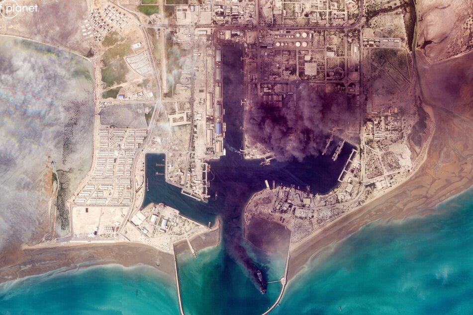
The US and Israel have conducted joint strikes against Iran since late February, prompting the Islamic Republic to retaliate with daily missile barrages targeting Israel and several neighbouring countries across the region.
Planet said the US government had asked satellite imagery providers to implement an "indefinite withhold of imagery".

"Effective retroactively from March 9, 2026, Planet is moving to a managed access model, extending the publication delay for all new imagery within the designated AOI (area of interest), and releasing imagery on a case-by-case basis and for urgent, mission-critical requirements or in the public interest," the company said in a message to clients received by AFP.
This area was defined in a previous announcement as all of Iran and allied bases in the area, as well as the Gulf states and existing conflict zones.
Planet, founded in 2010 by former NASA scientists and whose images are widely used by media and researchers, said it expected the new policy to last until the end of the conflict.
On March 10, the company said it would impose a two-week delay on access to its images of the Middle East because of the war, extending an initial 96-hour delay.
Vantor, formerly Maxar, the other major provider of satellite imagery, had also announced major restrictions.
Trump administration asks Planet Labs to stop sharing aerial Iran war photos
Under normal circumstances, Planet's images are available to its clients – including AFP – within hours of their satellites passing overhead, providing a valuable resource for businesses, researchers, and journalists, but also potentially for militaries seeking to target enemy military bases or radar sites.
US law provides that any company headquartered in the US that commercially operates high-resolution satellite imagery may be subjected to restrictions for reasons of national security or foreign policy.
In practice, satellite data providers, which operate under license, put in place restriction protocols in order to avoid sanctions.
Cover photo: - / 2026 PLANET LABS PBC / AFP