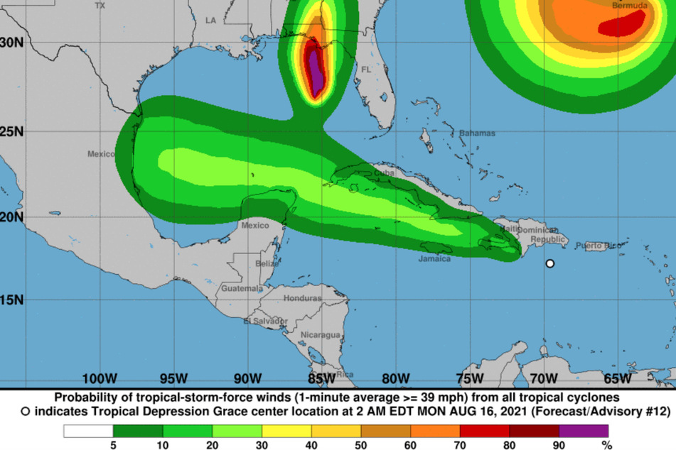
Florida spared Fred, but here comes Tropical Storm Grace
Miami, Florida - The weather system known as Fred officially fell apart Saturday morning as it moved into the Gulf of Mexico, still expected to soak South Floridians – who were already casting a nervous eye toward Tropical Storm Grace.

The National Hurricane Center’s 11 AM advisory downgraded Fred from a tropical depression to a disorganized wave with sustained winds of 35 miles per hour. Forecasters also discontinued a tropical storm warning for the Keys with the remnant center sitting about 125 miles southwest of Key West.
Fred had earlier been expected to emerge from its jaunt skirting the north coast of Cuba toward the Florida Keys. But over the past day, the storm’s track crept westward, a trend that continued early Saturday, sparing Miami-Dade and Broward counties the threat of tropical force storm winds. Rainfall could still come as the system moves up the coast – but perhaps not the flooding deluge expected earlier.
The storm’s location – well west of Key West – also lessened the chance of heavy flooding. The hurricane center said the Keys and southern Florida can still expect 3-5 inches of rain through Monday.
Still, Fred is expected to move over the warm gulf waters, enough to strengthen back into a tropical storm by Sunday with sustained winds of at least 45 miles per hours.
The hurricane center’s track called for the storm to approach the coast of Alabama by Monday afternoon.
Questions over impact on South Florida

For South Florida, the more pressing concern will be Grace, which as of the 11 AM advisory was 265 miles east of the Leeward Islands, moving briskly at 23 miles per hour toward Puerto Rico. The max sustained winds: 45 miles per hour. "Grace [is] a little stronger," hurricane specialist Robbie Berg wrote in an advisory.
The NHC placed a tropical storm warning for Puerto Rico, the British and US Virgin Islands, among other eastern Caribbean islands.
The hurricane center’s track on Monday had Grace passing over the Dominican Republic and Haiti, which on Saturday was dealt another devastating blow with a 7.2-magnitude earthquake. "Across Puerto Rico and the Dominican Republic, heavy rainfall may lead to flash, urban and small stream flooding, along with the potential for mudslides," Berg wrote.
Grace’s intensity may be affected by dry air, its interaction with the mountainous terrain of Hispaniola and wind shear, the crosswinds that can blow the tops off the towering cloud formations that glue hurricanes together.
It was still too early to tell how Grace might impact South Florida, where schools are slated to begin or have just begun – and where the Covid-19 crisis has mushroomed in recent weeks. The track, for now, has the storm close to South Florida by early Thursday as a tropical storm.
Computer forecasting models diverge on the storm’s path as it nears Florida. "The NHC track forecast splits this difference and continues to show a track running between Cuba and the Bahamas," the hurricane center wrote.
Cover photo: National Hurricane Center